
Yes! Finally on the road again. We had a one day rain delay, because who wants to start a tour on the only day of the week it's supposed to pour? Plus, one more day in Zurich is never a bad idea. But, Yes! On the road. And our first objective was to retrace our steps from the first touring summer, two years ago, when we went from Zurich to Brunnen, except that we'd stay west this time and go straight to Luzern after Zug. With that in mind, we headed downtown to the exact spot where we'd made our first wrong turn two years before and proceeded to go in approximately the right direction, but without being able to find the actual signs for the bike route we wanted to take.
Of course, two years ago we started with just the national map of Swiss bike routes - not helpful in the center of Zurich - and this year we did the same...
However, unlike two years ago, we went up and over the first ridge west of Lake Zurich and found ourselves in exactly the place we wanted to be - route 32! And it was lovely. Of course it was. This is Switzerland, and it's a bike route that is well marked and probably was planned by an actual cyclist.
We had one umleitung (detour) but the Swiss are conscientious even in unusual circumstances, so the detour had helpful signs.

Early in the afternoon we reached Luzern, and joined the path just where we had turned, coming in the other direction, two years ago. Things started to look familiar again. This time I got a photo of the tunnel tower.

But that's about it. Luzern is a beautiful little city and it was lovely to ride through again. We only stopped to buy some groceries (same Coop as 2 yrs ago) and then proceeded to our campsite, further down the road at Horw. The bike route goes around the long way, and we'd intended not to do that. We wanted to go directly and get to the campsite early, as well as not ruin our legs on the first day. 60 rather than 75kms for our first day back on the road. Alas, following the signs is so easy. The route is beautiful, with only a couple of tiring climbs, and we made it to our gorgeous campsite with plenty of time to settle in, eat dinner, and gape at Pilatus, the dragon-like peak above Horw.

The next morning we were greeted by Pilatus and a sunny and marvelous day. Bit of wind, but nothing dramatic. We packed up early and in record time. This year we decided we wouldn't have hot tea with breakfast, hoping to kick out lots of kms in the mornings. It seemed to have worked, although on average I think we tend to cycle the same number of kms no matter when we start or end our days.
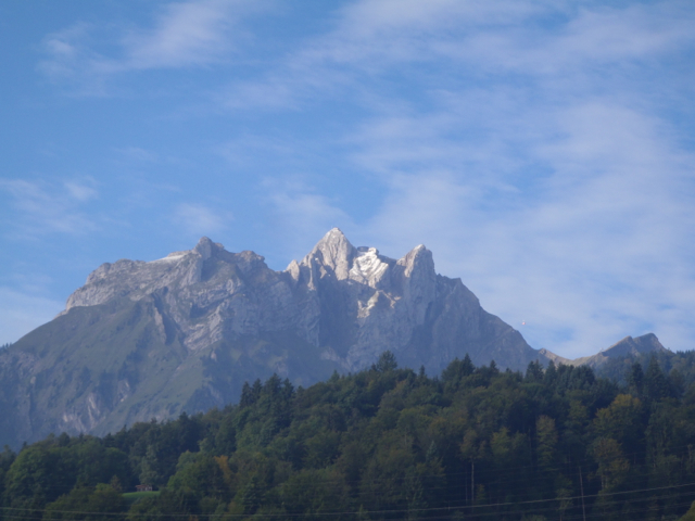
We could see Pilatus for the first couple of hours, because the route goes around the lake to the south, and then along a valley. We're in Alp country, but this was just a taster. The snow on Pilatus was from two days earlier - when all the passes were closed due to snow down to 1500m. Good thing we took that extra day in Zurich, I suppose.

Coming around the bend and into a new valley, we get our first glimpse of Alps

Gonna be a lot of this

Lunchtime by a stream - time to dry everything out
The morning involved a lot of flat, lovely riding through a beautiful valley with mountains on either side. At one point, the bike path went right across an airport runway. We managed to stay with the path and we saw a very large pond dotted by very large swans. We did start to climb a bit through a very sweet and quiet town, after which we went through a forest, where we found a perfect lunch spot where we could dry our dew soaked tent.
This is the day we were to climb up and over Brunigpass. The pass itself is at just over 1000 meters. Zurich is at about 400+ meters. We'd been going steadily up, but not fast enough to make this particular pass easy and quick. Quite the opposite. The route we took is National Route 9, which is called the Lakes Route, and we'd been meandering alongside lakes since Zug on this route. But for Brunigpass, we had to climb about 500 meters in just over 10kms. One stretch was a 200m climb in just 2kms. The grade averaged 12%. Joshua rode. Ramona walked.

See little Joshua? See how steep the grass part is?

First top!
We were very pleased with ourselves to have made it that far. It was hot and the path was unforgiving. We came from the far end of that little lake you can barely see in the background. We wished each other a happy birthday. Here the path seemed to be done going up, and we could tell that we were at the top, at least the top of that stretch. We were expecting a downhill on the other side. What we got was almost more spectacular. First, a view of some ... well... mountains.

Impressively, we didn't go down at all on the other side, besides the little road you see here. In the valley was a lake. We had climbed up to this notch in the scenery and on the other side was a big lake, way up high. A little stunned, but pleasantly so, we continued on. The path follows the quiet side of the lake and there were other people enjoying a lake-side ride here and there. Once in town on the far end of the lake we had a choice to make. Either we continue on and up and through the next stage of Brunig pass, or we camp there for the night. It was still pretty early. We only had a few, steep kilometers to go. Our next campsite would be in Meiringen, definitely on the other side. We found the local water fountain, refilled our bottles, and continued on up the hill.
I think the Swiss bike route website Veloland.ch recommends that this portion be done by train. Not far up the steep path, it turns to dirt and rock and is almost impossible to ride. Of course, if we had mountain bike tires or perhaps if we were carrying no weight, we might have been doing more pedaling and less pushing. As we were, it was a walk. But beautiful. We wished each other happy birthday again.

At the next "top" we were greeted by a small snack station. There is a special train that goes up to this spot and you can approach it by car from the other side. We decided to have some lunch and catch our breath. Then we continued on. Up, as it turned out. And at a really steep slope again, but this time paved. We emerged onto the main road as it curved around the seemingly final bend, and a sign told us we were at 1007m. Brunig pass. The direction we needed to go was along a road that did go a bit higher, at a really gentle slope, and brought us to an incredible view over the next valley and the town of Meiringen.

We stopped at a really nice little store for supplies, then made our way down the bike path, which is not paved most of the way, similarly steep to the climb on the other side, and gave us our first real hand work-out as we squeezed our brakes for all they were worth.
It was gorgeous. Once in town we toyed with the idea of a hotel, but places were expensive and we found out that there was a mo-ped rally going on so anything reasonable would have been booked anyway. We aimed for the campsite, which was stunning.

Our little tent
We bought a bottle of prosecco, ate a delicious camping dinner, and watched the mo-peds roll in. One friendly guy came by to find out just what we were up to. He also told us about the mo-ped rally. Their plan was to leave at 10am and climb Grimselpass, then go over Furka and loop back around to Gotthard and eventually end up in Meiringen again. Our plan for tomorrow? Grimselpass. Better get up early.
Happy Birthday.
No comments:
Post a Comment